Categories
Shopping cart (0 items € 0)
Advanced search

Middle East & Islamic World / Arabian Peninsula & Gulf States

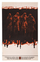
Propaganda poster for the unity of Arab peoples and the nationalization of oil

[OSPAAAL]. MARTINEZ, Olivio. Unity of the Arab peoples - Nationalization of oil.
[Cuba, 1972]. Poster (ca. 52.5 x 32.5 cm) printed in black and red, with an image of four armed Arabian horsemen, with Arabic text above and below, and with the title in Spanish, French and English at the foot of the poster, together with the logo of the OSPAAAL. Full description
€ 1,500
Order Inquire Terms of sale

The Ottoman-Mamluk war and the conquest of Mecca and Medina

[OTTOMAN-MAMLUK WAR]. Omnia que gesta sunt in Orie[n]te inter Sophi & Maximum Turcarum & Suldanum, & que[m]admodum dux Turcaru[m] caepit Alepum & Damascum & Hierusalem cum om[n]ibus circumiace[n]tibus oppidis, & quo[rum] maximus Turcaru[m] voluit audire una[m] missam apud sanctu[m] sepulchru[m] Iesu Christi.
[Basel, Pamphilus Gengenbach, 1518]. 4to. With woodcut illustration on title-page. 19th-century pink wrappers. [6], [2 blank] pp. Full description
€ 35,000
Order Inquire Terms of sale

Warmly inscribed by the author

PALGRAVE, William Gifford. Personal narrative of a year's journey through Central and Eastern Arabia (1862-63).
London and New York, Macmillan and Co., 1871. 8vo (ca. 13 x 19 cm). With a linen-backed folding map and 3 extending plans. Contemporary half morocco with maroon cloth over boards, gilt, front board stamped with the owner's initials "G.W.T.", marbled endpapers. [2], VI, [4], 421, [1] pp. Full description
€ 2,500
Order Inquire Terms of sale

One of the earliest sources on the Congo and central Africa, complete with all plates and maps

PIGAFETTA, Filippo and Duarte LOPEZ. Relatione del reame di Congo et delle circonvicine contrade tratta dalli scritti & ragionamenti di Odoardo Lopez.
Rome, Bartolomeo Grassi, [1591]. 4to. With an integral engraved architectural title-page (with the coat of arms of the dedicatee Antonio Migliore, Bishop of San Marco), large folding engraved general map of Africa (64×44 cm), large folding engraved map of the Congo (43.5×51.5 cm) and 8 numbered folding engraved plates of plants, animals and inhabitants of the country, by Natalis Bonifazio. Contemporary limp sheepskin parchment. [8], 82, [1], [1 blank] pp. Full description
€ 60,000
Order Inquire Terms of sale

The British admiralty’s pilot guide for the South Indian Ocean

[PILOT GUIDE]. South Indian Ocean pilot. Comprising Madagascar, Iles Comores, Ile de la Réunion, Mauritius, the Seychelles, the Chagos Archipelago, and other islands lying westward of longitude 80° East. Sixth edition.
London, hydrographic department, admiralty (colophon: printed by Butler & Tanner), 1946. 8vo. With two maps, to be used as an index, 10 plates and a few illustrations in text. Publisher's beige cloth.
With: Supplement no. 5-1956 relating to the South Indian Ocean pilot sixth edition, 1946 corrected to 23 April, 1956.
London, hydrographic department, admiralty (colophon: printed by Tinlling & Co., Liverpool), 1946. 8vo. With a loosely inserted folding plate illustrating the system of buoyage. Publisher's wrappers. XXX, 403, [1]; 46 pp. Full description
€ 750
Order Inquire Terms of sale

Only published edition of the original 1521 text of the navigation book of the great Ottoman admiral

PIRI REIS (Paul KAHLE, ed.). Bahrije. Das türkische Segelhandbuch für das Mittelländische Meer vom Jahre 1521.
Berlin and Leipzig, Walter de Gruyter & Co., 1926-1927. 3 volumes. Large 8vo (26 x 18 cm). Volume 1 with 137 reproductions of manuscript pages of Ottoman Turkish text and maps and volume 2 with 4 plates. Publisher's original printed wrappers. [1], [1 blank], [2] pp. + 64 ll. + [4], [1 blank], [1] pp.; ll. 65-137; [1], [1 blank], XLVIII, 88 pp. Full description
€ 2,500
Order Inquire Terms of sale
168 books found / Show all