Categories
Shopping cart (0 items € 0)
Advanced search

Middle East & Islamic World / Cartography & Exploration

Life and customs in the Ottoman Empire, described by a Christian former slave

DJURDJEVIC, Bartol (Bartholomeus GEORGIEVITZ) Voiage de la saincte cite de Hierusalem. Jointe la description des citez, villes, ports, lieux, & autres passages. Ensemble les ceremonies des Turcs ...
Liège, printed by Leonard Streel for Lambert de la Coste, 1600. 2 parts in 1 volume. 4to. 18th-century calf, gold-tooled spine. [32], [32] lvs. Full description
€ 17,500
Order Inquire Terms of sale

Afghanistan and its dependencies in Persia, Tartary and India, with 14 hand-coloured plates, in original wrappers

ELPHINSTONE, Mountstuart. Tableau du royaume de Caboul, et de ses dépendances, dans la Perse, la Tartarie et l'Inde, offrant les moeurs, usages et costumes de cet empire, ... traduit et abrégé de l'anglais, par M. Breton.
Paris, Nepveu, 1817. 3 volumes. 18mo. With 14 engraved plates depicting various costumes, lords on horseback, etc., all beautifully coloured by hand. Original publisher's printed wrappers, each volume with wood engraved illustrations on front, back and spine. Preserved in a modern gold-tooled green morocco box. XLIV, 189 [3]; [4], 222, [2]; [4], 223 [1] pp. Full description
€ 4,950
Order Inquire Terms of sale

A previously unobtainable set of magnificent wall maps by Nicolas de Fer

FER, Nicolas de. Set of four wall maps: America (1698), Africa (1698), Asia (1696), Europe (1695).
Paris, chez lauteur / van Loon, 1695-1698. Approximately 114.3 x 165.1 cm each. Copperplate engravings in original outline colour, tissue-backed for stability, laid down to modern cartographic linen. All with title banner dated 1698 with the Royal Privilege, and text panels dated 1703. Each map printed on four joined sheets with title surmounted and engraved text panels at sides and bottom. Full description
€ 850,000
Order Inquire Terms of sale

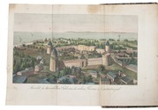
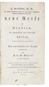
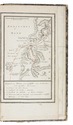
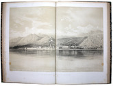
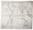
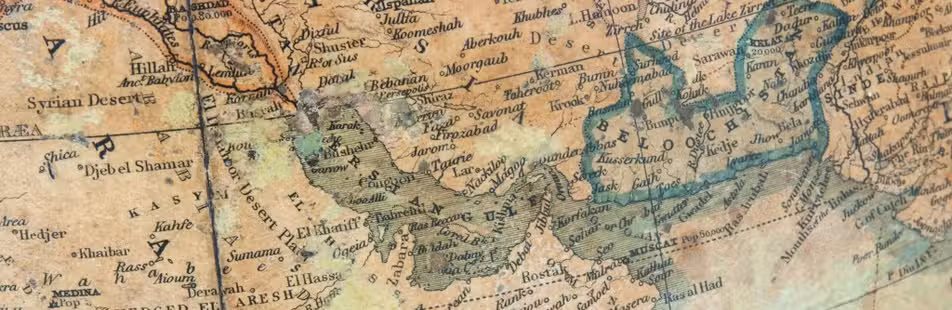
1565/66 pilgrimage to the Middle East, with author's portrait, coat of arms and 6 illustration plates

FÜRER VON HAIMENDORF, Christoph. Itinerarium Aegypti, Arabiae, Palaestinae, Syriae, aliarumque regionum orientalium.
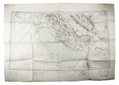
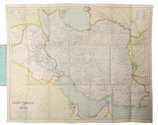
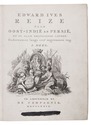
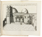
Nuremberg, Abraham Wagenmann, 1621 (colophon: Nuremberg, printed by Abraham Wagenmann, 1620). Small 4to. With finely engraved full-page portrait of the author by Peter Isselberg, full-page engraved Fürer von Haimendorf coat of arms, 6 folding engraved plates. Contemporary limp sheepskin parchment. [16], 118, [114] pp. Full description
€ 12,500
Order Inquire Terms of sale

A 1780s voyage through Turkey via Aleppo to Basra and via Muscat back to Europe

GRIFFITHS, John. Neue Reise in Arabien, die europäische und asiatische Türkey. Nach dem Englischen für Deutsche bearbeitet von K.L.M. Müller.
Leipzig, J.C. Hinrichs, 1814. 2 volumes bound as 1. 8vo. With an engraved folding frontispiece view and 3 engraved maps (2 large folding), the view coloured, 1 map with the Ottoman-Persian border coloured in blue and red, and all three maps with the route coloured in red. Mid 19th-century boards covered with marbled paper, with the arms of Friedrich Wilhelm IV, King of Prussia in gold on the front board. [10], 125, [3 blank]; [1], [1 blank], 154 pp. Full description
€ 2,500
Order Inquire Terms of sale

Over forty plates of East Africa based on daguerrotypes

GULLAIN, Charles. Documents sur l'histoire, la geographie et le commerce de l'Afrique orientale.
Paris, Arthus Bertrand, [1856-1857]. 3 text volumes and 1 atlas volume. Text volumes: 8vo; atlas volume: folio. With 55 tinted plates. Contemporary leather-backed marbled boards. XXXI, [1], 628; XXIII, [1], 556; [4], 527, [1 blank] pp. Atlas volume: [4] pp. and 55 plates. Full description
€ 35,000
Order Inquire Terms of sale

A magnificent copy of a classic world atlas, hand-coloured and sumptuously bound

HOMANN, Johann Baptist. Grosser Atlas über die gantze Welt.
Nuremberg, Homann heirs (printed by Johann Heinrich Gottfried Bieling), 1737[-1762]. Folio (34 x 53.5 cm). Letterpress title-page printed in red and black with an engraved map of the northern hemisphere in a polar projection, engraved frontispiece with a globe and a dozen allegorical figures (with a decorated cartouche at the foot giving the title in Latin), engraved portrait of Homann by Johann Wilhelm Winter after Johannes Kenckel, and 98 engraved maps (93 double-page, 1 larger folding in 2 sheets and 4 half-page together on a double-page plate) many with further inset maps and/or views, all with decorated cartouches, often with pictorial decoration or coats of arms; and 3 double-page engraved tables of topographic data. With the engraved title-page and all maps and tables (except for the small north polar projection on the letterpress title-page) coloured by an 18th-century hand, the maps in part or in outline. Gold-tooled red morocco (ca. 1800?) in a neo-classical style, from the workshop of or in the style of Georg Friedrich Krauss (Vienna). [3], [1 blank], 40 pp. plus frontispiece, portrait and 99 double-page plates. Full description
€ 85,000
Order Inquire Terms of sale

Globe made for the rulers of the Southerns Netherlands

[GLOBE - TERRESTRIAL]. HONDIUS, Jodocus. [Terrestrial globe].
Antwerp, Joan Baptist Vrients [produced by Jodocus Hondius in Amsterdam], Diameter (21 cm). The globe is assembled from 12 engraved gores, mounted over a hollow wooden sphere, the gores hand-coloured in outline, some areas with full colour infill. The zero meridian set at the Azores, the seas decorated with ships and sea monstors, the continents with several figures. The cartouche enclosing a lenghty adress to the reader by Hondius, pointing out the problems of determining longitude. A decorative cartouche set in North America crowned with the coat of arms of the Albert and Isabella Clara of Austria, the text below this cartouche is signed by Hondius and Vrients dedicating this globe to Albert and Isabella. The globe is mounted in a brass meridian circle set within a fixed brass outer circle, secured at the base into 2 brass plates supported by a brass rod rising from an carved wooden mount of ca. 1800. The walnut mount carved, into four faces each with scrolled cartouche divisions, one face with the carved coat of arms of Albert and Isabella. Overall height 50cm. Full description
€ 295,000
Order Inquire Terms of sale

Massive navigational directory for the East

HORSBURGH, James. The India directory, or, directions for sailing to and from the East Indies, China, New Holland, Cape of Good Hope, Brazil, and the interjacent ports ... third edition.
London, printed for the author and sold by Kingsbury, Parbury and Allen, booksellers to the East India Company (back of title-page: printed by Plummer & Brewis), 1826-1827. 2 volumes. 4to. Contemporary half calf, rebacked with the original backstrips laid down. [8], XXVI, 503, [1], 16; [8], 642, [1], [1 blank] pp. Full description
€ 15,000
Order Inquire Terms of sale
101 books found / Show all